With the wheat harvested the wheat fields are empty so it’s an ideal time to take soil samples from these fields.
You sample the soil to find out how much organic matter it has, how many nutrients like phosphorous and potassium it holds, and what the pH is. That gives you an idea on how much fertilizer and lime to apply. To do this you pull a core of soil about a 1/2 inch in diameter and 4 inches deep, and send it off to a lab to be analyzed.
It’s not quite that simple of course. One soil core isn’t very likely to be representative of the entire field, so we pull lots of cores. And the soil within our fields vary widely. Mixing the cores from different soil types might provide an average, but one area in the field might be rich and not need any additional fertilizer while another may need lots of fertilizer. Averaging that out would waste fertilizer on the rich areas and starve the poor areas.
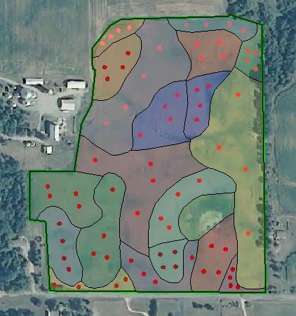
So we divide fields up into zones based on the soil types and keep the samples separate for each zone. Here’s the map of zones and sample points for one field[1].

Each of the reddish dots is a point in the field where we’ll pull soil samples. Each of the different colored zones are numbered to keep them separate.
We find the points in the field using this jim-dandy handheld computer with GPS[2].

Using this handheld computer I lay out a route through all the soil sample points and then we go through the field and it guides us to the next point.
We roar around the field in our UTV[3] pulling samples.

We keep all the samples for each zone separate in their own plastic tub in the back of the UTV.

The tubs are discarded deli salad tubs from Egolf’s IGA in Churubusco[4].
On the back of the UTV we have a place to hold the ‘current’ tub for the zone being sampled.

That way we don’t accidentally put a sample in the wrong tub or spill over into an adjacent tub.
Tom looks like he’s happily putting a sample into a tub.

But actually he was muttering, “don’t take my !@#$% picture.”
Tom, pulling a sample.

If you look back at the field map at the start of this post, you’ll see there are 20 zones in this field, and 4 sample points in each zone, and we pull 4 samples at each point. Yes, that’s 20 times 4 times 4, 320 samples for just this one field. Jump out, push the probe in the ground, poke the core out with your finger into a tub, and repeat. 320 times. For one field. And we have 30 fields. Some fields have fewer zones, some have more.
Soil sampling is so much fun that Pete, my Mom & Dad’s dog, decided he wanted to come along.

Pete’s on the right.
Here’s Pete and me having a special moment.

Doing soil sampling this way, and using the results to decide how to apply fertilizer is a win-win.
We win because we apply (and pay for) only the fertilizer we need. Every spot in the a field should get what it needs, not too much, not too little.
And we win again because we’re not applying excess fertilizer that would run off and eventually end up causing an algae bloom in the Gulf of Mexico.
I’m no fan of technology, but it is pretty cool when computers and GPS come together to let us do things like this.
1. This is the field featured in my previous post about harvesting rye.
2. zumbrun.net is, as always, entirely commercial-free. I’ve received no consideration from Trimble or SST for so prominently featuring their products. But, hey, Trimble or SST, if you want to, send me a big fat endorsement fee and I’ll see how deep my convictions run.
3. Polaris? You’re welcome to send me a check too.
4. Egolf’s IGA is the best grocery store ever. Bob Egolf? You don’t need to send a check.

Leave a Reply